Is anyone here a Cartographer (deals with maps) or is there anyone suitably qualified that can plot data onto an ordnance and survey map either in chart form or electronically so that there is a grid reference for every part of our clients ride?
It would need to be able to stand up to scrutiny from the defendants experts, so accuracy is the key, but it is we understand a specialist area.
Again, it is fee paying and we assume that given that there is 4 hours of data with a positional recording every 1 second (which is what I am told) there is probably a lot of work involved (unless told otherwise).
Any takers?
Any Cartographers or map makers here?
Moderators: Aladinsaneuk, MartDude, D-Rider, Moderators
Any Cartographers or map makers here?
It is better to arrive 30 seconds late in this world than 30 years early in the next


A work colleague of mine tracks his car journeys by GPS. There is a utility available that automatically converts NMEA (the standard in which GPS is encoded) into KML (Google Maps format) and allow the data to be automatically plotted onto Google maps.
This should give you all you need (I would have thought) and at a few clicks of a mouse.
I'll try to find the link to the utility for you.
This should give you all you need (I would have thought) and at a few clicks of a mouse.
I'll try to find the link to the utility for you.
“Scientists investigate that which already is. Engineers create that which has never been.”
-- Albert Einstein
-- Albert Einstein
Even better - it seems that Google Earth 5.2 can import NMEA logs directly - Result!D-Rider wrote:A work colleague of mine tracks his car journeys by GPS. There is a utility available that automatically converts NMEA (the standard in which GPS is encoded) into KML (Google Maps format) and allow the data to be automatically plotted onto Google maps.
This should give you all you need (I would have thought) and at a few clicks of a mouse.
I'll try to find the link to the utility for you.
http://gis.stackexchange.com/questions/ ... google-api
Google Earth 5.2 supports GPS NMEA data:
"Added file import types: NMEA (.log and .nmea), Garmin GDB, Garmin Training Center, and Ozi Explorer files can now all be read. Garmin fitness extensions are now read from GPX. Extended data for Elevation Profile and Track is handled when available"
http://earth.google.com/support/bin/ans ... swer=40901
http://earth.google.com/intl/en/download-earth.html
“Scientists investigate that which already is. Engineers create that which has never been.”
-- Albert Einstein
-- Albert Einstein

Trouble with GPS is accuracy. it only need to lose signal from the satellite/s momentarily and the position will be out of kilter.
GPS is inaccurate at the best of times unless youre running a military magellan, etc, in which case theyre still only accurate down to say a 10 figure grid at best.. (1 metre square) but even then thats subject to number of satellites, etc
Walk a straight line with a GPS.. lets say a 600metre length of twine pulled tight between two points and then walk back 20 mins later. Do this on any average day.
The lines wont be straight and will be out by a fair few metres.
Never ride faster than your guardian angel can fly
Yes - clearly nothing can be done about the fundamental accuracy of the data. That just needs plotting "as is". It really depends on what you are trying to get out of the information. For a pretty accurate track of the overall journey it will be very good. Any significant anomalies will be obvious. If you want to know where things were to the nearest 10cm at a specific moment in time - well you won't be able to get that with any degree of confidence - but I doubt that is what is required.
“Scientists investigate that which already is. Engineers create that which has never been.”
-- Albert Einstein
-- Albert Einstein
Thanks for that, but we already have it plotted onto a Google map and the QC is not happy with the detail as we need to get to the point where we can show the riders deviation down the the nearest foot.D-Rider wrote:A work colleague of mine tracks his car journeys by GPS. There is a utility available that automatically converts NMEA (the standard in which GPS is encoded) into KML (Google Maps format) and allow the data to be automatically plotted onto Google maps.
This should give you all you need (I would have thought) and at a few clicks of a mouse.
I'll try to find the link to the utility for you.
This case is going to go to trial which is why Google is insufficient as it has to stand up to scrutiny from the defendants expert, so we actually need the OS co-ordinates for every second of his journey which is why it needs apparently a specialist.
It is better to arrive 30 seconds late in this world than 30 years early in the next
quite right - standard GPS will not give you that accuracy to any reasonable level of confidence.
Sorry but it's not the fact that you are plotting it on Google maps but the fundamental data that is the problem.
I've worked with GPS systems since 1995 when I led a team that developed one of the first in-car navigation systems to be introduced in the country - I do know what I'm talking about here.
“Scientists investigate that which already is. Engineers create that which has never been.”
-- Albert Einstein
-- Albert Einstein
Just to back up what Kwakerz and Andy are saying, and what we have said in the earlier thread,
The location data is recorded 'as is' based on what the satellites think the device is. This is usually in a longitude/latitude format.
a GPS route is essentially a long list of longitude /latitude co-ordinates recorded by the device. These are then plotted onto a map to give an indication of route.
Let me show you a real example.
The following block of data is a 30 second extract from my run yesterday. It is a .GPX file which is essentially a fancy version of XML.
The first spot latitude of 53.22894, longitude of -0.548449, elevation of 103.4 feet, and the timestamp was 16:11:42. At this point, the reading is about 1.5 meters from where I know I actually ran.
http://goo.gl/maps/W7Z8q
The second spot is latitude of 53.229094, longitude of -0.548695. elevation of 109.2 feet, and was recorded at 16:11:50 (8 seconds since the last point) At this point, it is at least 10 meters out from the path I ran down. Also, there is no record of where I was for 8 seconds, or an indication as to the path I took.
http://goo.gl/maps/Pavau
The third spot is latitude of 53.229241, longitude of -0.549425, elevation of 52 feet and was recorded at 16:12:03. 13 seconds after the last spot was recorded.At this point it is atleast 6 meters from where i actually ran, and i guarantee that I had not climbed a 3 story building.
http://goo.gl/maps/f5OyK
Also look at these images.
The first image shows the run I tracked as a whole It provides a good indication as to where I ran geographically.
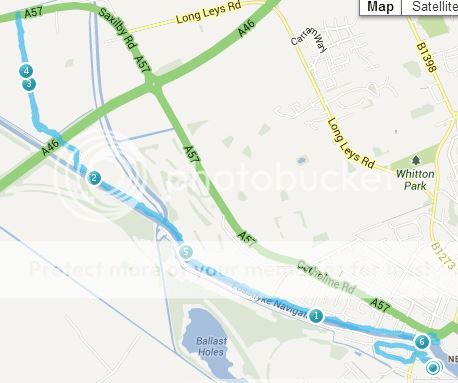
However, when we zoom in closer, we can see the individual points and the lines connecting them.
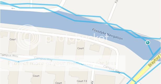
I can categorically confirm to you that I was not jumping in and out of the river constantly. That would be a bit strange.
Now, you and I both know that the recorded points are not precisely where I ran but that is there the GPS receiver was told it was by the GPS satellites. There is no extra accuracy hidden in the latitude or longitude co ordinates, that is exactly where the phone thought it was.
To change any of the recorded points would be post rendering and what you would end up with is a nicely plotted map, but it would in no way represent the data recorded by the device. It would never ever hold up in court.
Unless the GPS device was able to record frequent and accurate location data (every second, maximum) and was accurate to within a foot, then you will have a hard time using this as evidence in court.
I'm sorry if what I have posted above seems a bit harsh, but Its the truth. You simply cannot get away with manipulating the data.
Anyway, I hope it helped? Took me long enough to make this post :P
The location data is recorded 'as is' based on what the satellites think the device is. This is usually in a longitude/latitude format.
a GPS route is essentially a long list of longitude /latitude co-ordinates recorded by the device. These are then plotted onto a map to give an indication of route.
Let me show you a real example.
The following block of data is a 30 second extract from my run yesterday. It is a .GPX file which is essentially a fancy version of XML.
Each trkpt element represents a piece of data recorded. It shows latitude, longitude, elevation, and the timestamp recorded for each point.<trkpt lat="53.22894" lon="-0.548449">
<ele>103.4</ele>
<time>2013-07-04T16:11:42Z</time>
</trkpt>
<trkpt lat="53.229094" lon="-0.548695">
<ele>109.2</ele>
<time>2013-07-04T16:11:50Z</time>
</trkpt>
<trkpt lat="53.229241" lon="-0.549425">
<ele>52.0</ele>
<time>2013-07-04T16:12:03Z</time>
</trkpt>
<trkpt lat="53.229386" lon="-0.549654">
<ele>55.8</ele>
<time>2013-07-04T16:12:09Z</time>
</trkpt>
The first spot latitude of 53.22894, longitude of -0.548449, elevation of 103.4 feet, and the timestamp was 16:11:42. At this point, the reading is about 1.5 meters from where I know I actually ran.
http://goo.gl/maps/W7Z8q
The second spot is latitude of 53.229094, longitude of -0.548695. elevation of 109.2 feet, and was recorded at 16:11:50 (8 seconds since the last point) At this point, it is at least 10 meters out from the path I ran down. Also, there is no record of where I was for 8 seconds, or an indication as to the path I took.
http://goo.gl/maps/Pavau
The third spot is latitude of 53.229241, longitude of -0.549425, elevation of 52 feet and was recorded at 16:12:03. 13 seconds after the last spot was recorded.At this point it is atleast 6 meters from where i actually ran, and i guarantee that I had not climbed a 3 story building.
http://goo.gl/maps/f5OyK
Also look at these images.
The first image shows the run I tracked as a whole It provides a good indication as to where I ran geographically.

However, when we zoom in closer, we can see the individual points and the lines connecting them.

I can categorically confirm to you that I was not jumping in and out of the river constantly. That would be a bit strange.
Now, you and I both know that the recorded points are not precisely where I ran but that is there the GPS receiver was told it was by the GPS satellites. There is no extra accuracy hidden in the latitude or longitude co ordinates, that is exactly where the phone thought it was.
To change any of the recorded points would be post rendering and what you would end up with is a nicely plotted map, but it would in no way represent the data recorded by the device. It would never ever hold up in court.
Unless the GPS device was able to record frequent and accurate location data (every second, maximum) and was accurate to within a foot, then you will have a hard time using this as evidence in court.
I'm sorry if what I have posted above seems a bit harsh, but Its the truth. You simply cannot get away with manipulating the data.
Anyway, I hope it helped? Took me long enough to make this post :P
No no no no no!Dalemac wrote:
The location data is recorded 'as is' based on what the satellites think the device is. This is usually in a longitude/latitude format.
............................................................
Now, you and I both know that the recorded points are not precisely where I ran but that is there the GPS receiver was told it was by the GPS satellites.
The satellites have absolutely no idea where your device is. Your GPS device is purely a receiver and does all the clever bit of working out where it is.
The satellites broadcast the Almanac (basically the where the satellites will be at any moment in time), the id of the satellite and a very accurate time-stamp derived from the atomic clock on board.
Your receiver will receive this information from a number of satellites knowing where the satellites are and the distance they are away from you (derived from the delay between transmitting and receiving the time-stamp), it's a simple matter of trigonometry to work out where you are.
The accuracy is improved where the receiver can see many satellites and where the spread of satellites is good. As I mentioned before, multi-paths etc degrade accuracy.
“Scientists investigate that which already is. Engineers create that which has never been.”
-- Albert Einstein
-- Albert Einstein
Thanks again for the input.
When it comes to things that are techno like this I have very little idea, so I am learning all the time, I stick to the easy stuff like the legal side, riding dynamics and liability areas , not the technical side of things like GPS
I am going to get a bit more information on Monday from the guys in the office and I may well get back to you on this.
Thanks again guys.
It is better to arrive 30 seconds late in this world than 30 years early in the next
-
flatlander

- Eprom Test Pilot (Stig)
- Posts: 3097
- Joined: Tue Jun 14, 2011 9:06 pm
- Location: cheshire
as an aside can I point out that given the almost unique nature of this statement I would probably go with him on thiis oneD-Rider wrote:... I do know what I'm talking about here.
For the avoidance of doubt and for the benefit of my wife, not everything I may say here will be absolutely true I may on ocassion embellish a little for effect.
That said when it comes to motorbikes, I like to ride side saddle with a nice frock
That said when it comes to motorbikes, I like to ride side saddle with a nice frock