Just to back up what Kwakerz and Andy are saying, and what we have said in the earlier thread,
The location data is recorded 'as is' based on what the satellites think the device is. This is usually in a longitude/latitude format.
a GPS route is essentially a long list of longitude /latitude co-ordinates recorded by the device. These are then plotted onto a map to give an indication of route.
Let me show you a real example.
The following block of data is a 30 second extract from my run yesterday. It is a .GPX file which is essentially a fancy version of XML.
<trkpt lat="53.22894" lon="-0.548449">
<ele>103.4</ele>
<time>2013-07-04T16:11:42Z</time>
</trkpt>
<trkpt lat="53.229094" lon="-0.548695">
<ele>109.2</ele>
<time>2013-07-04T16:11:50Z</time>
</trkpt>
<trkpt lat="53.229241" lon="-0.549425">
<ele>52.0</ele>
<time>2013-07-04T16:12:03Z</time>
</trkpt>
<trkpt lat="53.229386" lon="-0.549654">
<ele>55.8</ele>
<time>2013-07-04T16:12:09Z</time>
</trkpt>
Each trkpt element represents a piece of data recorded. It shows latitude, longitude, elevation, and the timestamp recorded for each point.
The first spot latitude of 53.22894, longitude of -0.548449, elevation of 103.4 feet, and the timestamp was 16:11:42. At this point, the reading is about 1.5 meters from where I know I actually ran.
http://goo.gl/maps/W7Z8q
The second spot is latitude of 53.229094, longitude of -0.548695. elevation of 109.2 feet, and was recorded at 16:11:50 (8 seconds since the last point) At this point, it is at least 10 meters out from the path I ran down. Also, there is no record of where I was for 8 seconds, or an indication as to the path I took.
http://goo.gl/maps/Pavau
The third spot is latitude of 53.229241, longitude of -0.549425, elevation of 52 feet and was recorded at 16:12:03. 13 seconds after the last spot was recorded.At this point it is atleast 6 meters from where i actually ran, and i guarantee that I had not climbed a 3 story building.
http://goo.gl/maps/f5OyK
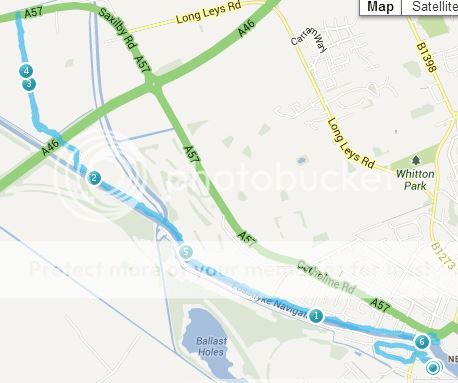
Also look at these images.
The first image shows the run I tracked as a whole It provides a good indication as to where I ran geographically.
However, when we zoom in closer, we can see the individual points and the lines connecting them.
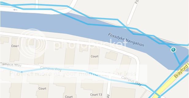
I can categorically confirm to you that I was not jumping in and out of the river constantly. That would be a bit strange.
Now, you and I both know that the recorded points are not precisely where I ran but that is there the GPS receiver was told it was by the GPS satellites. There is no extra accuracy hidden in the latitude or longitude co ordinates, that is exactly where the phone thought it was.
To change any of the recorded points would be post rendering and what you would end up with is a nicely plotted map, but it would in no way represent the data recorded by the device. It would never ever hold up in court.
Unless the GPS device was able to record frequent and accurate location data (every second, maximum) and was accurate to within a foot, then you will have a hard time using this as evidence in court.
I'm sorry if what I have posted above seems a bit harsh, but Its the truth. You simply cannot get away with manipulating the data.
Anyway, I hope it helped? Took me long enough to make this post :P

